
Bay Shore, Menominee, Michigan (circa 1910)
Dear George,
Every week or two I put a
vintage postcard image of my home town, Menominee, Mich., in the righthand
column of this blog. Because these
aren’t saved when I delete them, I’m putting a previous batch of them here as
an archive in a permanent file.
One can also access four previous Menominee Postcard “archives” (posted
on 6/26/10, 2/5/11, 6/17/11, and 1/11/12) by going to the blog’s righthand
column, scrolling down to “Labels”, and clicking on “Archives”. In addition to these earlier Menominee
postcard archives, the reader will also find there an archive of “Marinette
Postcards” (posted 11/25/10), Menominee’s sister city across the river in
Wisconsin, and archives of my father’s family photos taken in Menominee in the
1940’s and 1950’s (“Vic’s Photos”, posted 12/12/09 and 8/17/11). I’ll add additional archives for these
categories in the future.
Love,
Dave

MENOMINEE
AND MARINETTE (from 10,000 ft. altitude)
This is a sensational view of
the twin cities. I’d say it was
taken in the 1940's. You can see
the immense significance of water for these communities. The upper half of the picture is Green
Bay. The waterway which runs
downward through the center of the photo is the Menominee River (the state
boundary between Michigan and Wisconsin).
The town of Menominee is on the left; Marinette is on the right. The bridge near the mouth of the river
(barely discernible) is the Menekaunee Bridge. The major bridge near the middle of the photo which connects
the centers of the two towns is the Interstate Bridge (U.S. Highway 41). Stephenson Island is located under the
Interstate Bridge, near the Marinette shore. There's also a bridge and a dam just below the Interstate
Bridge in the picture. That's the
Hattie St. Bridge. Following down
the river, at the junction of its sharp curve, is a second dam. At its left is the Riverside
Cemetery. And just above the
cemetery is the Riverside Country Club golf course. The road that runs off at the lower left is Riverside
Boulevard where our family lived from the late 1940's to the 1960's (our house
being located about a mile past the bottom of the picture). Back toward the top, along the Green
Bay shore toward the left you can make out the marina breakwater which is
located at Menominee's business district.
My grandfather's drugstore, my dad's law office, and Washington Grade
School were located near the lefthand end of the breakwater. All in all, this is the world in which
our family and friends lived, and it's pleasing to see the entire area in a
single photo.

OGDEN AVENUE
Ogden Avenue is Menominee’s
major east-west thoroughfare, running from the Green Bay shoreline at its
eastern end to the Hattie Street Bridge and the paper mill at the west. Travelers heading north from Wisconsin
cross the Interstate Bridge and enter Menominee on Ogden Ave., then follow it
till Highway 41 turns to the north near the courthouse. Our family lived on Ogden Ave. for my
first five years, and it was the main route for my mother’s baby carriage walks
with me and then Steven. I believe
that Ogden Ave. was named for William B. Ogden, a Chicago mayor and Director of
the Chicago and North Western Railroad, who developed the settlement of
Peshtigo as a lumber mill company town and was instrumental in extending the
C&NW Railroad from Green Bay to Marinette and Menominee in order to ship
lumber to Chicago.

SNOW ON MAIN ST., 1909
My early memories of
Menominee include huge snowstorms that piled up windswept banks of snow that
came up to my chest. I think my
memory of the frequency of such storms is grossly exaggerated today. Menominee gets about 53 inches of snow
a year, more than double the 24 inches in Cincinnati, but dramatically less
than the 210 inches in Marquette.
During my childhood we probably got a couple of storms of the magnitude
shown in this photo. They were
very exciting because they meant multiple vacation days from school.

THE
EPIPHANY CHURCH
The Epiphany Church, located
at 1016 Ogden Ave., was originally a branch of the St. John's Catholic parish
in Menominee (founded in 1872), but it withdrew from the Mother Church in
1890. The church's foundation was
laid in 1891, and the church was dedicated on Nov. 13, 1892. Construction cost $35,000. Epiphany added a school in 1902. After more than half a century, a
shortage of teaching nuns forced the school to close, and in 1964 Epiphany, St.
John's, and St. Ann's merged their school systems into Menominee Catholic
Central.

MENEKAUNEE
BRIDGE (ca. 1910)
As
teens we used to drive around the "loop" through the twin cities,
crossing the Interstate Bridge into Marinette, going up Main St., then
returning to Menominee, Sheridan
Road, and Ogden Avenue via the Menekaunee Bridge. The latter was a drawbridge which opened up for large boats
and ships entering the Menominee River.
We always got annoyed when we had to sit “endlessly” in a line of cars
waiting for a sailboat to pass through.
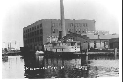
CARPENTER
COOK BUILDING
The
Carpenter Cook Building was located on the Menominee River near the north end
of the Menekaunee Bridge. One of
our good family friends, Francis S., was an executive for this grocery
wholesale distribution company.
Some of my neighborhood chums from Washington Grade School used to go
swimming at the Carpenter Cook docks, but I never joined them. Many years later I learned that the
river was badly polluted near its mouth, so it was just as well that I’d been
wary.

THE
MENOMINEE RIVER SUGAR COMPANY (ca. 1910)
Menominee's
sugar beet factory, the third largest in the nation, opened for business in
1903, supported by the town's wealthy lumber enterpreneurs. The factory was designed to produce
1,000 tons of sugar beets per day, though only 14,000 tons were processed in
its first season. The area's low
temperatures were not conducive to sugar beet farming. The beet crops were sufficient to keep
the factory going but not to encourage expansion. By 1955 the equipment was exhausted and the company closed
its doors.

RIVER
SCENE AT MENOMINEE, MICH.
This
scene is from the early 1900’s.
These were the glory days of the Menominee River. The town's population was 16,000, about
6,000 higher than in my youth and 7,000 higher than today. There were only remnants of the turn of
the century lumbering operations leftby the time we were growing up on the
river in the 1940’s and 50’s, but we were aware of the historical importance
the industry to our area and sometimes pretended that we were lumberjacks,
balancing ourselves on dried out logs that we had towed home from Pig
Island.

NORTH PIER LIGHT
Menominee was (and is) a
significant Great Lakes Port, including being a destination for commercial
shipping, leisure craft, and the Ann Arbor Carferry which ran to the Lower
Peninsula. As children, we were
mostly out of touch with the town’s commercial shipping industry, though one of
my high school classmates was to become a seaman on the boats.

OGDEN AVENUE (1915)
For my first five years our
family lived in a big white house at the foot of the Interstate Bridge on Ogden
Avenue. This is a photo taken a
block or two from our house, looking east toward Electric Square and the Green
Bay shore. My grandfather VAL
Sr.’s drugstore was at the end of the street on the left at the intersection
with Sheridan Road. My mother used
to take me and my infant brother Steve on walks down Ogden Ave. to the Office
Supply Store. I’d get to buy a
pencil or an eraser. It was my
favorite place to go.

FUN ON THE BEACH
I don’t remember this
particular bevy of beauties from the 1940’s, and I don’t think that this
generic postcard really depicts the Menominee shoreline. But it does capture the spirit of
Menominee in the summertime. A
number of our friends – O’Hara’s, Caleys, Sargents, Mars, Jacobsen’s – lived on
the Green Bay shore just north of the city, and we would spend a lot of time
swimming in the Bay or sunning on the sand. It truly was fun on the beach.

AERIAL VIEW, YACHT HARBOR
(ca. 1950)
Menominee’s downtown business
and shopping district is mainly on Sheridan Road which runs along the shore of
Green Bay. The breakwaters, which
harbor local and visiting sail and powerboats, are at the center of downtown,
with Marina Park visible here toward the left side of the harbor. The big white building in the center of
the picture is the Montgomery Ward Building which also housed the Lloyd
Theater. The street which runs
from near the right end of the breakwater toward the top of the picture is
Ogden Avenue, the town’s other major thoroughfare. Looking up Ogden Ave., one can see the Interstate Bridge
which runs across the Menominee River to Marinette. Near the top of the picture is the dam which spans the
river. A lot of memories are
contained in this picture.

AERIAL VIEW, DOWNTOWN
MENOMINEE
This is another view of
Menominee’s downtown business district looking north from its southern
edge. The breakwater is at the
right, with Marina Park and the Bandshell facing it. The building at the south edge of the park is a bank, and
our dentist and Riverside Boulevard neighbor, Dr. Mead, had his office on the
second floor. My mother, my
brother Steve, and I lived in the apartment building directly across the street
from the bank during World War II when my dad was away in the navy. The large building toward the lower
left of the picture is the Menominee Opera House which had been converted to a
movie theater by the time of my childhood. We grade school children paid a dollar to get a booklet of
ten tickets to the Saturday afternoon matinees where we watched Roy Rogers and
Dale Evans, Gene Autry, Hopalong Cassidy, the Marx Brothers, Charlie Chan, The
Three Stooges, the Lone Ranger, and many more.

RUSTIC BRIDGE, HENES PARK
We enjoyed Henes Park on
Menominee’s outskirts a lot as kids and teenagers, but it became still more
important when we returned home for visits as adults and parents
ourselves. We’d take our son J
over to see the buffalos and deer in the deer yard, stop by the pond to watch
the ducks, look at the bear and raccoons in the mini-zoo, go swimming at the
beach, do kiddie rides at the playground, and enjoy a popsicle at the beach’s
refreshment stand.

HOTEL MENOMINEE DINING ROOM
(ca. 1945-50)
I’m sure our family must have
eaten in the Hotel Menominee on occasion.
However, when I asked my dad in adulthood about our family’s eating out
during my childhood, he said that we never ate out because we never had enough
money to do so. Anyway the
Hotel Menominee was a fine old establishment on Sheridan Road along the Green
Bay shore. When I was in fourth
grade, our Washington School glee club performed there in a concert for the
local Lion’s Club, much to the enjoyment of the Lions and their spouses. The hotel burned down in 1977.

LOG JAM ON THE MENOMINEE
RIVER (ca. 1910)
The Menominee River, as I’ve
mentioned, was the site of the nation’s largest lumbering production in the
1890’s and early 1900’s. In our
youth, the river was the site of numerous deadheads, and we’d watch out for
them when navigating our rowboat with its 1.5 hp. motor. The channel which separated Pig Island
from its neighbor was filled with water-logged stumps, and every now and then
we’d pick out a fancy one and tow it home behind the boat.


No comments:
Post a Comment