Map: The Menominee River and Surroundings
Dear George,
Growing up on the Menominee River, we had a keen awareness of the river’s impact on our daily lives. However, we had only the sketchiest knowledge about the river in its entirety -- its history, importance to the region, or how its attributes varied over its lengthy course. It is truly remarkable. At 118 miles, the Menominee is the longest river in the U.P. and serves as the interstate border between Michigan and Wisconsin through its entire course. Over 100 tributaries flow into the Menominee between its source and its mouth at Green Bay, and its total basin covers 4,070 square miles. Here are some postcard images which help tell the river’s rich story.

Coolidge Summer White House on the Brule River (circa 1928)
The Menominee River is formed at the junction of the Brule and Michigamme Rivers in the northwestern U.P. about ten miles north of Iron Mountain. Like the Menominee, the 52-mile Brule and the 67-mile Michigamme Rivers were visited by European explorers in the 1700s; then traders, trappers, and missionaries in the eighteen and nineteenth centuries, becoming important logging sites in the 1890s. In 1928 President Calvin Coolidge made his Summer White House on an island in the Brule River where he fished and learned trap shooting.

Below Compressor Falls, Menominee River, Iron Mountain, Mich. (circa 1910)
Shortly after its point of origin, the Menominee River passes next to Iron Mountain, one of the U.P.’s historical iron ore mining cities, and then Norway, Mich. Iron Mountain is the home of the former Chapin Mine, location of the largest steam-driven pumping engine in the U.S., and the Midwest’s largest bat colony.

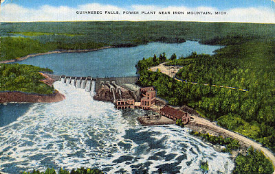
Quinnesec Falls Power Plant on the Menominee River near Iron Mountain (circa 1950)
The Hydroelectric Plant at Big Quinnesec Falls on the Menominee River, three miles west of Iron Mountain, went into operation in 1949 and is the largest of the river’s nine power plants. Its generators produced about 220 trillion watts of electricity in 2007. The Quinnesec Paper Mill, also located on the Menominee, is the U.P.’s largest.

Piers Gorge on the Menominee River (circa 2000, photo)
Below Iron Mountain, the river drops at a rate of five feet per mile, generating a lengthy stretch of whitewater rapids. Near Norway, the 100-foot forested cliffs of Piers Gorge on the Menominee offer one of the deepest whitewater gorges in the Midwest, extending four miles. Sporting a 10-foot waterfall drop, Piers Gorge is too dangerous for boats or canoes, but attracts expert kayakers from around the nation. Bald eagles live in the gorge’s rock bluffs.

Grand Rapids Reservoir on the Menominee River (circa 2000, photo)
For most of the hundred miles below Iron Mountain and Norway, the Menominee River winds its way through largely unpopulated, forested land with no adjoining towns or villages. Large reservoirs have been created along the river’s course which have formed the region’s deepest and most pristine lakes and offer outdoor recreational opportunities, e.g., camping, fishing.

Log Jam on the Menominee River at Menominee and Marinette (circa 1910)
Historically, the Menominee, along with the Saginaw and the Muskegon, was one of the three most productive logging rivers in Michigan and Wisconsin. The great years of lumbering in the U.P. and northeastern Wisconsin were from the early 1840s to about 1910. The Menominee River Boom Company was founded in 1866. In 1899 it processed 4,250,000 logs, making Menominee the largest lumber shipping port in the world. The last Menominee River logging drive was held in 1917.

Second Dam, Menominee River Between Marinette and Menominee (circa 1910)
To aid in bringing logs down the river, the Boom Company built a total of 44 dams on the Menominee and its various tributaries.

Saw Mill, Marinette, Wisc. (circa 1910)
The first sawmill was built on the Menominee River in 1831 by William Farnsworth and Charles Brush on what's now Riverside Avenue in Marinette, and the first steam sawmill was built in Menekaunee (now eastern Marinette) in 1856. By 1895 there were 22 sawmills on the river, 9 on the Marinette side and 13 on the Menominee side. One historian wrote that Menominee “became indescribably busy with fleets of schooners carrying boards, laths, shingles, and beams down to the Chicago docks and yards.”

The Four Seasons Island Resort, Menominee River near Pembine (circa 2000)
As it enters Menominee and Marinette Counties, the Menominee River begins to be more populated. A long-existing landmark is the Four Seasons Island Resort which is located on the 100-acre Miscauno Island in the Menominee River near Pembine in Marinette County. The Four Seasons was originally opened in 1905 by the Wisconsin and Michigan Railroad. It was a favorite retreat of Chicago gangster Al Capone and his cronies in the 1920’s and ‘30’s. Capone had his own glass-walled suite which enabled him to keep an eye out for intruders from both the Marinette and Menominee county sides of the river.

Hattie St. Bridge and Menominee River Paper Mill, Marinette, Wisc. (circa 1910)
The twin cities of Menominee and Marinette grew and prospered because their location at the mouth of the Menominee River enabled the shipment of huge volumes of lumber to Chicago and other Great Lakes cities. With the demise of the logging industry in the early 1900’s, paper mills and related industries became the backbone of the local economy.

Aerial View (from 10,000 feet) of Menominee (left), Marinette (right), and the Menominee River (circa 1940s)
The Menominee River is still central to industry in the twin cities. Today two paper mills, a chemical company, two wastewater treatment plants a shipbuilding company, and a foundry are located on the river in Menominee and Marinette.

Draw Bridge from Menekaunee Dock, Marinette, Wis. (circa 1910)
Three vehicle bridges cross the Menominee River between Menominee and Marinette: the Hattie St. Bridge to the west; the Interstate Bridge (Highway 41) in the middle; and the Menekaunee Bridge on the east. The Menekaunee Bridge is a drawbridge which allows for the passage of big Great Lakes ships into the Menominee River harbor and its various commercial and industrial loading docks.
There’s a lot more that might be said, of course. For my purposes, though, I think it’s quite amazing to contemplate how the river shapes communities, the economy, and people’s lives. It’s no wonder that we think that the Menominee River affected our lives. That’s been true for millions of others too.
Love,
Dave
SOURCES:
www.wikipedia.org (“Menominee River”, “Menominee, Michigan”)
www.michigandnr.com (“Menominee River/Piers Gorge”)
www.menominee.genwebsite.net (“Menominee County History”)
Google Images (“Menominee River postcard”, “Menominee River”, “Piers Gorge”)
G-mail Comments
-Gayle C-L (1-7): David, Ur amazing Thank you always for these wonderful letters… Lots of love. G :).


No comments:
Post a Comment